
MOUNTAIN | Chased By A Typhoon in Mt Arayat
Traversing The Extinct Stratovolcano On A Stormy Weekend
Its an outdoor adventure with added challenges. Chased by the approaching landfall of Category 1 Typhoon Kalmaegi locally named as Tropical Storm Luis which was expected to make landfall over Cagayan Valley of Northern Luzon on the same day as our planned Mt Arayat traverse.
Mountain Facts
- Mount Arayat is an extinct Stratovolcano.
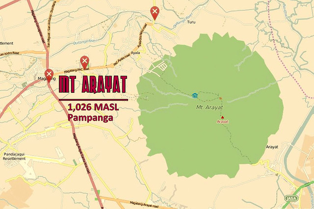
- Rising to a height of 1,026 MASL (3,366 FASL).
- Located within the Municipality of Arayat and Magalang, Pampanga.
- The mountain is considered a mystical one, the legendary home of Aung/Aring Sinukuan/Sinkuan/Suku or the Fairy known as diwata Mariang Sinukuan depending on which version of the story the readers or listeners prefer, but in ancient Kapampangan folklore as well as the research known to have been gathered by Kapampangan students of Henry Otley Beyer, it was and is the abode of Apung/Aring Sinukuan, rival of Namalyari of Mount Pinatubo, who is in varying versions, the son of Cargon-Cargon who was mortally wounded in a fight with a giant from the Zambales Mountain Range which is said to be the home of Apu Namalyari. (Source: Wikipedia Mount Arayat)
DENR Registration Site, they take donations instead of entrance fee.
Trail Traverse
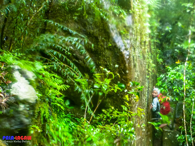
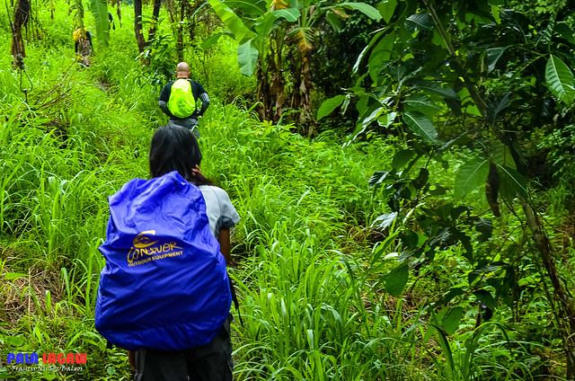
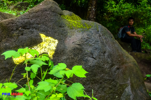
Assault via Brgy Ayala, Magalang, Pampanga, North West of the Mountain where large grottos of Stations of the Cross are placed. The new trail is established following the power lines reaching the Mt Arayat North Peak Campsite at 1026 MASL where the Telecom tower is situated. This trail is forrested with many tree tunnels making the hike easy. Not much challenge except the continues steep slope with few Rock Boulders. This side of the mountain has trail markers in yellow, painted in rocks and huge boulders. The North Peak campsite is a bare patch of land, the highest point of Mt Arayat itself.
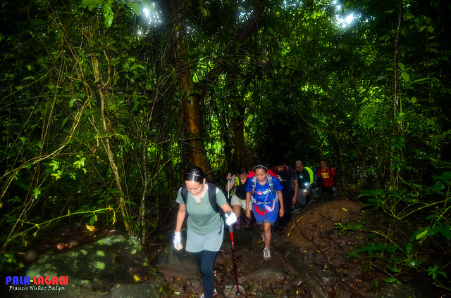
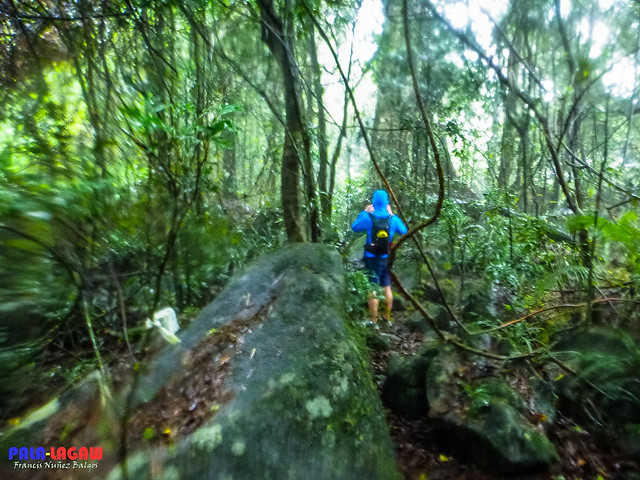
From the North peak, descending to the South peak is a challenge especially to first time hikers. Vertical clay and rock walls with rope segment abound making this a Technical Climb and not easy after all. The Andesitic dome known as White Rock is along the way and once the South grassy peak is reached, you can look back and realise that you just circled the broken Amphitheater like Caldera. Thickly forrested trail, Banyan Trees with extended long vines constantly block the way, creeping Bamboo grasses are abound too. The descent will surely test the toughness of one's knees, rocky all the way down, I dare not run in this trail. Since this climb is besiege with Typhoon, the trail is filled with running water, it was like walking on a canal, we just followed the waters direction untill we reached the DENR office in Brgy Juan Bano, Arayat.

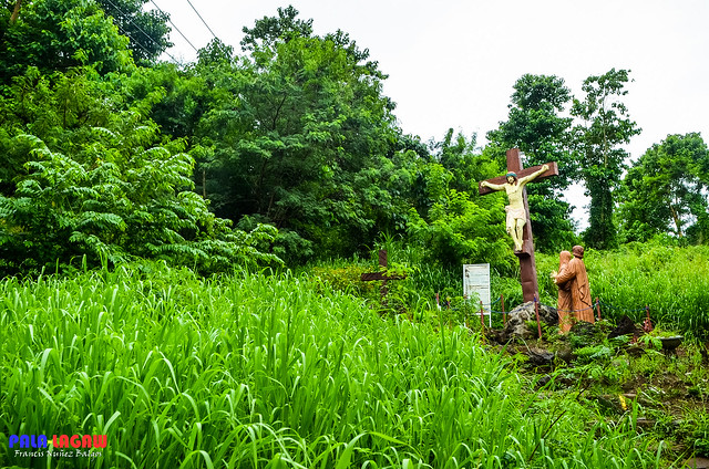
A fork in the trail, this particular grotto has to be noted, as this is where the trail breaks to the left side, the straight way is a dead end.
Why Climb When The Storm Is Coming?
A training climb with outdoor friends, we are all preparing for the epic traverse of Mt Apo
the Grandfather of Philippine Mountains in the next 2 months. In all
honesty, I haven't done anything as daring as climbing a Mountain with
an approaching severe Tropical Storm in our tails. Sure, I've raced the
Philippines Highways of the Kalinga
comfortably sitting inside a bus while floods, rain swept roads and
swaying palm trees can be seen from the bus windows. I've woken up from a
lavish resort room of Pamarta Bali in Morong
Bataan expecting a beautiful beach sunrise to photograph only to find
myself in middle of a Signal Number 3 Storm (Signals numbers are
used to categorized the strength of Storms/Typhoons in the Philippines).
These weather disturbance never fazed me, I was born and raised Visayan, and this country being Archipelagic,
closer to the Philippines Equatorial South and right smack in the
Pacific Ring of Fire, Typhoons and Tropical Depressions are a regular
occurrence. There are those typhoons that become historic in the wake of
devastation they bring, as always, its easy to forget and move on
fixing what was broken, eventually remembering just the good things that
happen.
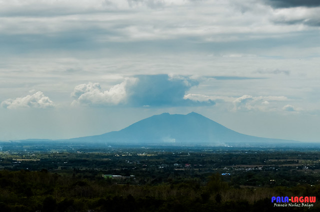
Mt Arayat is an extinct Stratovolcano proudly standing like a lone Island in the flat plains of Pampanga with 1,026 MASL,
with steep slopes littered with Rock Boulders, pristine trails within
forested areas that passes through the broken Caldera that we now call
the Northern and Southern Peaks. This mountains stands with a proud
silhouette all over the towns that surrounds its base, it cast a wide
shadow that it can be seen even from neighboring provinces like Bulacan, Nueva Ecija, Zambales and Bataan.
Days
before the climb, reports of the approaching Typhoon is a baddest of
Bad News for every outdoors men. Knowing the responsibilities and
rigours of wet climbs, our Team Lead decided to push it through against
strong caution, the Storm is expected to make landfall by midnight by
which time we should be safely back in our homes sipping hot coffee in
the middle of raging winds and heavy rains. We took calculated risk, and
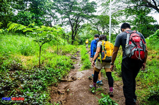
with 12 souls we decided to brave Mt Arayat expecting to be drenched by rain water, its part of the training anyway, as we would be expecting a wet climb in Mt Apo.
Suggested Itinerary And Notable Expenses
Prepared by Mye Enrile
Entry point: Brgy. Ayala, Magalang, Pampanga
Exit point: Brgy. Juan Bano, Arayat, Pampanga
LLA: 15.2067N, 120.7441E, 1,028 meters above seal level / 3,379 feet
Days required / Hours to summit: 1-2 days / 5 hours (North Peak) 8 hours (South Peak)
Specs: Technical Major climb, Difficulty 5/9, Trail class 1-4 (10kms)
0300 Assembly at Victory Liner Cubao EDSA south bound.
0400 ETD Terminal
0500 ETA SM Pampanga
0530 Take jeep bound to Magalang
0630 ETA Magalang Jollibee, breakfast, take tricycle to Brgy. Ayala (jump off)
0730 Commence trek
1100 ETA North Peak (summit), lunch
1200 Resume trek, head to South Peak via ridge
1300 ETA Haring Bato
1400 ETA South Peak
1430 Descent
1630 ETA Bgy. San Juan Baño, Arayat
1730 Take tricycle to bayan, then jeep to SM Pampanga
1800 ETA SM Pampanga, dinner/snacks/post-climb
2000 ETA Manila
NOTE: We hired a jeep on our arrival in SM Pampanga to take us to Brgy Ayala for the first registration, and the jump off.
- Bus: Cubao to San Fernando, Pampanga - Php 102
- Jeep: San Fernando to Magalang - Php 35
- Tricycle: Magalang to Bgy. Ayala registration desk (jump off) - Php 70/trip
- Tricycle: Bgy. Juan Bano to bayan - Php 50/trip
- Jeep: to SM Pampanga - Php 25
- Bus: San Fernando to Manila - Php 102
- Guide: Optional, Php 400-500 range.
- Hiring a Jeep from SM Pampanga is an option if within a group, this eliminates all the tricycle expenses. Amount is negotiable with the driver, depending on the number of climbers.
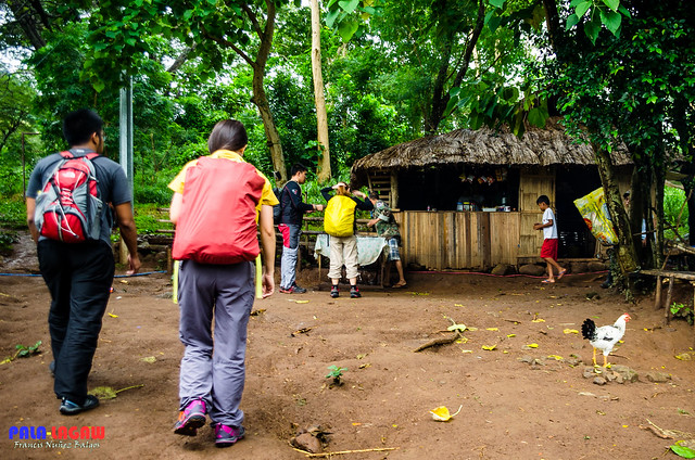
The Ayala side of Magalang do not require registration fee, only guide fee ranging from Php 400 - 500 and donation when passing the DENR entrance guarded by the Philippine Army. Each hiker or group of Hikers needed to be logged as this station would be responsible for rescue efforts if something where to happen.
Brgy Juan Bano requires Php 20.00 registration fee wether you are Ascending or Descending on their side. Unfortunately, the rumors of extortion is well noted on this side. Caution is given in making negotiations like hiring a guide for traverse.
Ang Pala-lagaw Photo Gallery
These photos are all published in my Flickr Account.
Click here for more: Mt Arayat Traverse


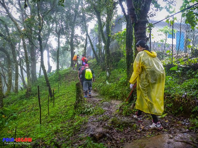
Military prescence is prevalent here since Mt Arayat as once an abode of Rebels and NPA's.
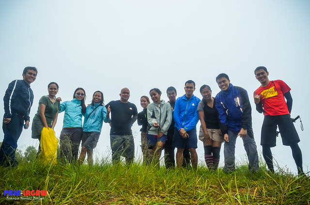
Here we are, the only 12 souls that braved the wrath of Typhoon Kalmaegi. We ate our packed lunch from this site, before our descent to the South Peak.

L to R: Dona and Joanne, ready for the torrential rain and smiling. They are also training for Mt Apo traverse.
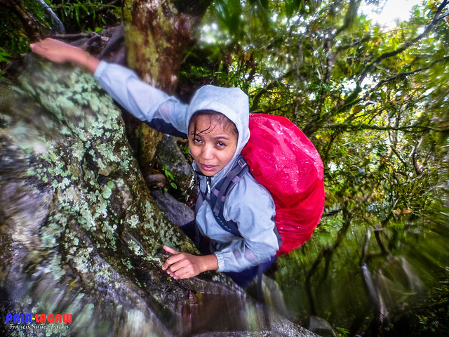
The rock wall with rope segment. Surprisingly, the women in this hike were the strongest hikers we have, leading the trails in breakneck speed and yes, even this rock climbing part. Lovely in here was shrieking in fear before she decided to climb this slippery rock on her own. It's just like her to complain that she is tired, but then you'll see her running the trails when they are flat. Makes you realise that you can never judge a girl's strength by fragile appearance.
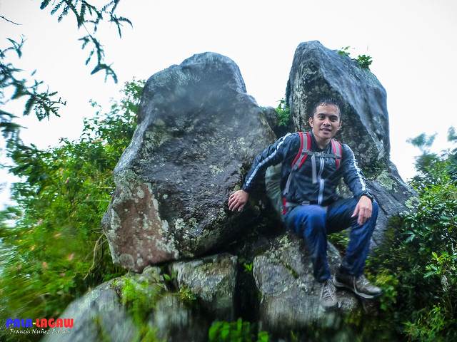
This is me, drenched by the torrential rain all over.
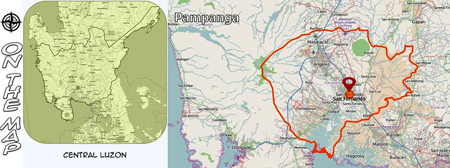
On The Map

Follow Me

All Rights Reserved
Pala-lagaw reserves the right for any watermarked pictures posted
No pictures should be downloaded or copied without permission from the blogger.


nice travel blog.. keep it up!
ReplyDeleteSir, naa ka contact number sa guide didtoa?
ReplyDeleteHello Po..
Deletehindi po required ang guide dun, pero kung kailangan mo ng guide, pasabi ka lang sa DENR Registration Site.. Sila magbibigay ng guide. :)
Whoa! This is very challenging. The trails looks very steep plus the rain!
ReplyDeletehi Sir,
ReplyDeleteit will be our first climb to this mountain.
is it okay if will not hire a guide?
like what we did in batulao and pico de loro, we're all 1st timers yet we did not hired a guide.
okay po kung ayaw mg hire ng guide..
Deleteword of caution lang kung hindi pa sanay umakyat saka mag basa ng trail signs.. Madali lang ang trail from Ayala side, pero yung papuntang Bano side medyo tricky.
Kung me BMC naman kayo Sir okay na siguro yun.
okay sir, ito nalang...mas mahirap ba ang trail sa arayat-bano side compare sa pico at batulao? pertaining to what you've mentioned "medyo tricky".
DeleteYung pa akyat from Ayala, saka yung pababa to Bano side Sir.. madali lang.. straightforward lang yun.. yung tricky part, crossing from Peak 1 to white rock peak 2. Ridge line ang ibang part nun, saka forrest area. :)
Deletesalamat sir!
Deletesa white rock nga yung tricky. sa RH kmi bumaba nung una, buti nlng nakita ng kasama ko trail sign. sarap balikan, kaso ang dami basura. yung mga umakyat iniiwan mga bote ng tubig nila.hays.
9.5hrs namin natapos yung akyat...:D
DeleteIts done na sir Mina.. it has become a marker for the Jump Off. :)
ReplyDeletePlano ko po sana umakyat sa arayat dis coming april 3rd week. Kaso ang hirap maghanap nang guide na traverse.. Merun nga, kaso ang mahal.. 1k ang price sa dayhike.. Kung ikaw alam mo ang trail dun, pwdi mo ako makontak sa 09356211782.. And name ur price po. Maraming Salamat.. Ingat po. Ralph..
ReplyDeleteAakyat ako this tuesday. June 2
ReplyDeleteSana may makasama ako. First time ko rin
09229818312
rain while hiking, be careful.
ReplyDeletePeople managed to not only the hard-hearted, but also a hard worker who believes in her abilities
ReplyDeleteSarap lang mag hiking habang umuulan basta palaging mag ingat. Great job guys, I like the photos you have shared. :)
ReplyDelete---
where to go in Pampanga