
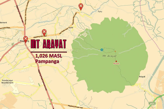
Mt Arayat Ayala-Juan Bano Traverse (ArTrav) 1,026 MASL
Mountain Trek Guide
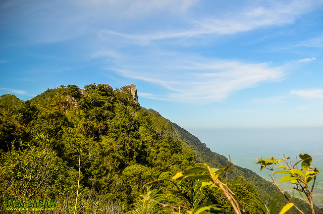
Mt Arayat is an extinct Stratovolcano proudly standing like a lone Island in the flat plains of Pampanga with 1,026 MASL, with steep slopes littered with Rock Boulders, pristine trails within forested areas that passes through the broken Caldera that we now call the Northern and Southern Peaks. This mountain stands with a proud silhouette all over the towns that surrounds its base, it cast a wide shadow that it can be seen even from neighboring provinces like Bulacan, Nueva Ecija, Zambales and Bataan.
Mountain Facts
|
Trail Notes
The blogger has traversed Mt Arayat on the same Ayala - San Juan Bano Trail twice last September 2014 and January 2015. See Chased By A Typhoon In Mt Arayat.
Assault via Brgy Ayala, Magalang, Pampanga, North West of the Mountain where large grottos of Stations of the Cross are placed. The new trail is established following the power lines reaching the Mt Arayat North Peak Campsite at 1026 MASL where the Telecom tower is situated. This trail is forrested with many tree tunnels making the hike easy. Not much challenge except the continues steep slope with few Rock Boulders. This side of the mountain has trail markers in yellow, painted in rocks and huge boulders. The North Peak campsite is a bare patch of land, the highest point of Mt Arayat itself.
From the North peak, descending to the South peak has a few challenge especially to first time hikers. Vertical clay and Rock walls with rope segment abound making this a Technical Climb and not easy after all. The Andesitic dome known as White Rock is along the way and once the South grassy peak is reached, you can look back and realise that you just circled the broken Amphitheater like Caldera. Thickly forrested trail, Banyan Trees with extended long vines constantly block the way, creeping Bamboo grasses are abound too.
From the North peak, descending to the South peak has a few challenge especially to first time hikers. Vertical clay and Rock walls with rope segment abound making this a Technical Climb and not easy after all. The Andesitic dome known as White Rock is along the way and once the South grassy peak is reached, you can look back and realise that you just circled the broken Amphitheater like Caldera. Thickly forrested trail, Banyan Trees with extended long vines constantly block the way, creeping Bamboo grasses are abound too.
Once the descent has started from the South Peak side, it becomes a continues rocky trail untill you reached the open plains and paved road in San Juan Bano side.
Suggested Itinerary
Entry point: Brgy. Ayala, Magalang, Pampanga
Exit point: Brgy. Juan Bano, Arayat, Pampanga
Dayhike of Estimated 8 Hrs, 10 kms.
0300 Assembly at Victory Liner Cubao EDSA South Bound.
0400 ETD Terminal
0500 ETA SM Pampanga
0530 Take jeep bound to Magalang, Pampanga.
0630 ETA Magalang Jollibee, breakfast, take tricycle to Brgy. Ayala (jump off)
0730 Commence trek
1100 ETA North Peak (summit), lunch
1200 Resume trek, head to South Peak via ridge
1300 ETA Haring Bato
1400 ETA South Peak
1430 Descent
1630 ETA Bgy. San Juan Baño, Arayat
1730 Take tricycle to bayan, then jeep to SM Pampanga
1800 ETA SM Pampanga, dinner/snacks/post-climb
2000 ETA Manila
NOTE: We hired a jeep on our arrival in SM Pampanga to take us to Brgy Ayala for the first registration, and the jump off.
Estimated Expenses
Bus: Cubao to San Fernando, Pampanga - Php 102
Jeep: San Fernando to Magalang - Php 35
Tricycle: Magalang to Bgy. Ayala registration desk (jump off) - Php 70/trip
Tricycle: Bgy. Juan Bano to bayan - Php 50/trip
Jeep: to SM Pampanga - Php 25
Bus: San Fernando to Manila - Php 102
Guide: Optional, Php 400-500 range.
Hiring a Jeep from SM Pampanga is an option if within a group, this eliminates all the tricycle expenses. Amount is negotiable with the driver, depending on the number of climbers.
Hiring a van from Manila is also an option.
Brgy Ayala side of Magalang do not require registration fee, only guide fee ranging from Php 400 - 500 and donation when passing the DENR entrance guarded by the Philippine Army. Each hiker or group of Hikers needed to be logged as this station would be responsible for rescue efforts if something where to happen.
Brgy Juan Bano requires Php 20.00 registration fee wether you are Ascending or Descending on their side. Unfortunately, the rumors of extortion is well noted on this side. Caution is given in making negotiations like hiring a guide for traverse.
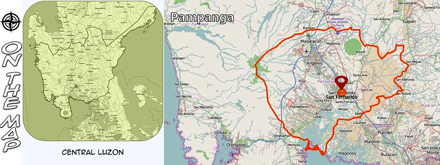
On The Map
Ang Pala-lagaw Photo Gallery
These photos are all published in my Flickr Account.
Click here for more: Mt Arayat Traverse

One of Mt Arayat's trail resident.
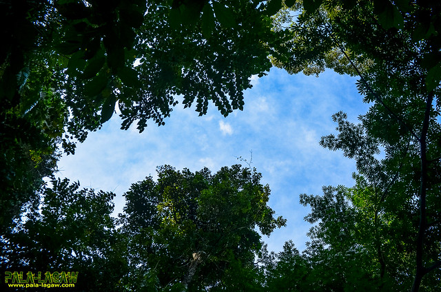
Some parts of forested trail has open canopy.
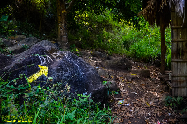
Trail markers in the Ayala side are painted in rock boulders.
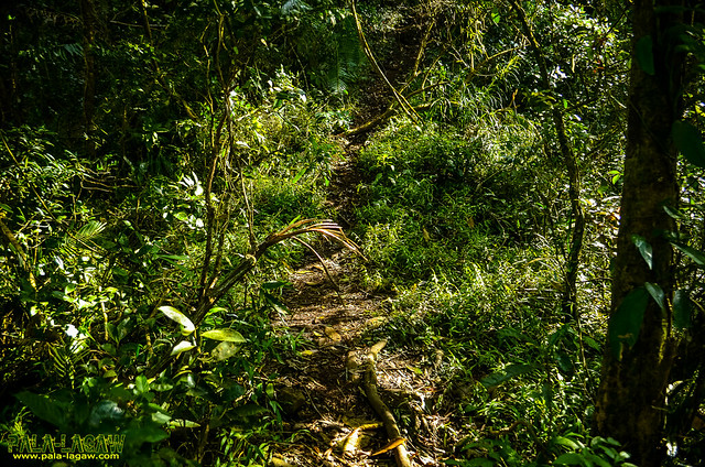

Tree tunnels make the assault hike pleasant.
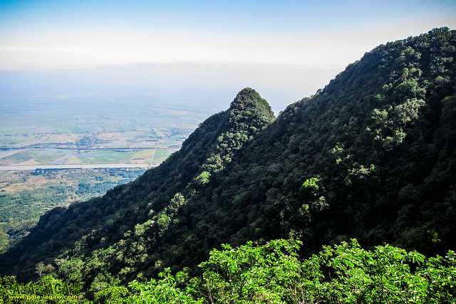
Peak 2 or sometimes reffered to a South Peak as seen from Peak 1 (North Peak).
The summit is a bare patch of land, serves as the campsite and location of the tower and police outpost.

Before that climbing down a vertical rock wall is this site with the sweeping view of Pampanga plains.

Follow Me

All Rights Reserved
Pala-lagaw reserves the right for any watermarked pictures posted
No pictures should be downloaded or copied without permission from the blogger.


Can you provide guide contact for Mt. Arayat hike po? Thanks po for the reply.
ReplyDeleteGuide will be offered when you register.
DeleteSorry I cant provide any reco for that.
If I were to drive here, any guarded/safe parking slots near the jump-off? :)
ReplyDeleteIf I were to drive going here, are there any guarded/safe parking areas near the jump-off? :)
ReplyDeletehi. thanks for conquering mt.arayat. the peak 2 you are referring in the picture is not the south peak. it is the pinaccle peak. fyi, the the north peak is the highest, second is the south and the small one is the pinaccle.
ReplyDeletegood day ! ask lang po is it good for a beginner or not po ? mas mataas po ba ito kesa sa mt. maculot of batangas ? thanks po.
ReplyDeletei want to do this climb...
ReplyDelete